Showing posts with label scouts. Show all posts

Friday, 17 November 2023

Pioneering for Scouts and Cub Scouts - Ladders. A-Frames. Tripods. Make then and climb on them use them.

Start with simple but satisfying and fun pioneering projects e.g. Ladder. A-Frames. Tripods. It is very important to really USE the item made. Climb on it. Carry people with it. Have fun.

There is enough for lots of programme here but danger of information overload!

Pick one thing to try at a time.


https://troopleader.scouting.org/troop-meetings-pioneering/

GAME AND CHALLENGE IDEAS

Patrol Challenge: A-Frame Transport Race


A-Frame rope walker

Patrol Challenge: Ladder Building Activity

Also can use ladder as stretcher. Ladder as chariot (drag one end).

A 'pole' ladder is the more traditional type of ladder. This simply involves choosing two strong spars of the required length and attaching rungs at regular intervals using a square lashing. One important thing to note is that the two main uprights are not parallel to each other. They should be angled inwards towards each other as you go to the top of the ladder. This will prevent the rungs from slipping downwards.

I suggest that you test the strength of each rung (and lashing) carefully before using the ladder.
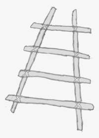
Ladder

pioneering.pdf Classic Pioneering doc, pictures of Bridges, Catapults, Towers, Gadgets. 2 copies are printed out in pioneering folder in scout press(good luck finding it though! :-P 

pionprojects.pdf and funwithropes.pdf Older docs 50s/60s quite good. Lots more text description.


pioneer4patrol.pdf including Trestle chariot race.


knots_knot_notes.pdf Nice pictures of 15 knots and explanation of use. Quiz at the end.


HOW this can work at your scout Camp or Meeting


BEFORE MEETING/ACTIVITY:

1. Pick one thing like making a ladder and plan one or more games that could be done with the ladder/thing that is made.

2. Have a look at resource/video can help you and can share with other Scouters so they know the plan.

3. Find a picture of what you want Scouts to make (to help explain - have a print out or find in scout press or have on your phone).

AT MEETING/ACTIVITY:

DO a safety talk while fallen in or in circle: (make it quick)

    Ask the Scouts themselves how to do the activity/later challenge/game safely 

    Remind Scouts of usual rules not too many in stores at same time (limit ?2 per patrol). 
    Remind Scouts that camp/pioneering area is work area, everyone should be alert and watching out for spars/tools swinging / catapults being unleashed / splinters / things flying through air / ...

    Check with Scouts do they know first aid for - head injury / other ...


Brief Sixers/Seconders/PLs/APLs on what the project is. (show them picture)

   Remind them to build project well - there will be a challenge to use it after,

   Remind them to keep patrol working and ask for Scouter support.

   Remind Sixers/PLs to lead by example work-wise but they are a Leader so their first task is to keep their patrol Working/Happy/Spirit/Engaged (Scouters keep and eye and help with this also where needed but without making it obvious)


Delegate it to Sixers/Seconders/PLs/APLs to get started, figure out what they need, get stuff from stores and to Scouters to help keep people safe. Scouters can dive in and help where needed but hands-off is better.

Trust your scouts to be safe but also monitor and remind them and adjust things if something looks dangerous.


Teach people who don't know knots/lashings (this is a challenge - Scouters can help here also)

Keep everyone in Six/Patrol working/happy/engaged.

If interest is waning then encourage to stick with it and encourage to go faster and get things completed.
 

Added challenge might be to time the build, also Scouters evaluate how the Six/Patrol is working - leadership from Sixer/Seconder/PL/APL - team work from all the Six/Patrol - work ethic - neatness - working safely - and Quality of lashings and end product.

CHALLENGE MENTAL/PHYSICAL FUN/GAME:

Brief the Sixers/PLs at start of each game. Stop and review/change things with Scouts input if something is not working or is dangerous.

Stand the thing up - Patrol making it secure - and put 1 or more Scouts on it.

Run the game like chariot race / stretcher race / Alligator crossing / ...

Review and escalate the challenge, make it more difficult. Make course longer, add more turns. Finish up with EPIC course outside fire exit, over to fence by road, UP onto the bank and along, around a tree, back into hall by front door. SCOUTERS be ready to supervise each patrol and guard hall entrances.


Tuesday, 7 March 2023

Campfire song: There are no bananas in the sky

Great song 🙂 tune very close to .. Heads, Shoulders, Knees and Toes. There are no .. bananas in the sky, in the sky, There are no .. bananas in the sky, in the sky, But there’s a sun, And a moon, And a coconut cream pie (dramatic pause) But there are no bananas in the sky, in the sky! (Actions on NO, bananas, sky, sun, moon, coconut cream pie) The action words are also louder and more dramatic and No and Pie are long. Coconut cream pie of course is a massive planetary object much bigger than the Sun and Moon. Repeat going silent on another action word each time until penultimate verse: There are (action) (action) in the (action) in the (action) There are (action) (action) in the (action) in the (action) But there’s a (action), and a (action), and a (action), But there are (action) (action) in the (action), in the (action)! And finish up very dramatically with all the words back in.

Thursday, 20 October 2022

variant of game - server room twister jenga yoga tai-chi frogger ...

New game for Scouts or engineering geeks maybe ;)
Good idea triggered by comment from a work colleague of mine.

Server rooms come in all sorts of shapes and sizes.
Some are well organised and others have more chaos!
When you work in them you often have to step carefully and elegantly and dodge and twist around equipment and cables.
Especially if you are debugging you might have to move in new equipment and search for boxes and follow different cables and plug in / un-plug and re-plug cables.
It can become quite an epic single-person twister jenga yoga tai-chi game!

This is maybe less common now with servers moving to cloud managed in big datacentres which are probably more organised with respect to cable routing and connectivity.
Even the area behind your TV should be getting more simple.

Anyway.

Game is a bit like jenga as well as twister - with elements of yoga and tai-chi - and frogger(slippy log croc dodging river crossing).
You don't hold the position like twister (unless a really cruel session of routing re-plugging multiple cables is needed! - or indeed cleaning optical cables before connecting)
In real life server rooms without a map lots of the clambering can be needed to just find the right boxes and ports.
I have had great fun in past.

Ideal location and equipment:

Old decomissioned server room with some old unused boxes, cables(power, ethernet and other), etc etc
Old network routers and modems are good which do not have a fixed home in rack so they end up on top of or under other boxes or just on the floor.
Probably best not to use live electrical sockets - a selection of power extension cables is needed.
Other unconnected electrical and telephone/modem sockets are optional.

Add in old household modems and TV/audio-visual and computer equipment of any sort.
You can also include kitchen appliances - anything with plug and cable.

Alternate location:

An area with a specific boundary - room or carpet or map (or tent?).

Alternate "equipment":

You can make pretend machines from cardboard boxes or other with ports for connecting rope cables. Get people to bring any WEEE(Waste Electrical and Electronic Equipment) and bring all to recycling centre after you are done.

Audit equipment and cables and floor space.

Label each cable end as A or B

Make a random choice generator for 1. items of equipment 2. cables and end A or B
Optional random generator for specific port in each equipment(optional) matching cable.

Play:

Run random choice generators.

You must take the item of equipment and plug specified cable end into a compatible port.
(into the specified port if playing that variant)

You may move the item of equipment (as long as some other item of equipment or cable doesn't fall or break).

You cannot stand or bash into cables or equipment.

As the game runs you cannot unplug items.
The room should get more difficult to navigate as game progresses.
It would be good to keep some sort of order so that clutter is not too bad but .. well .. see how it goes.
You could setup room at start with heavy equipment down middle or at sides e.g. real server racks or fridges/...

Decoration: disco balls, shiny blinky lights, ...

Have fun!

Empty server room racks


Network router on floor under debug console

Debug console on pile of PCs

Further reading:

https://www.theregister.com/2016/01/22/cabling_horrors/

https://www.dreamstime.com/photos-images/messy-server-room.html


Friday, 14 October 2022

Route card for Kippure Hike - komoot app works nicely

You can use App like e.g. komoot.com to help draw route and fill in route card details.
komoot is the latest favourite as you can draw route on phone or at computer.
You can take distances travelled and height gain/loss from app.
App also helps estimate pace - komoot adjusts estimate depending on incline and track type and surface.
I have been doing a few route cards in google sheets.

Add a new tab duplicate of Blank Template when new route is to be done:
Anyone should be able to view that and make a copy for their own use.
Be careful if sharing - you don't leak your hike details to general public until after you do your hikes.
Access restricted but I can share it if you would like to see - just request access.

PROCEDURE: Duplicate route card Blank Template ...

0. fill in title, date, start time 1. Draw route in app and publish. 2. Fill in each waypoint description (following your route in app). 3. fill in Grid ref/lat long and Altiture and Total dist (use app) Optionally use irish.gridreferencefinder.com to fill in ITM grid refs 4. for each segment (view route and select segment can help) fill in Bearings, height climb/fall and incline, length 5. fill in route note e.g. "no path" "follow forest track then hill path" 6. Add up segment lengths and altitude gain/loss and check with total. 7. Fill in estimated time (time with no breaks) 8. add in break/lunch/view point/other stop times 9. Add in Escape notes. 9. Review card, verify distance, height gain/loss, surface and times. 

Break complicated legs into 2 or more by adding rows. 

Route can be shared first with other Scouters and with Scouts for planning.


Print to .pdf and share for non google sheet users.

https://drive.google.com/file/d/1r4q_XtAPxNcmxoSoyZgkX_pZ9Tr-MDOV/view?usp=sharing .pdf

 (access restricted but I can share no problem it after we have done hike - just request access)

e.g. also save .gpx and .kml files from App for load into other map apps and other uses:

https://drive.google.com/file/d/14QGkl4F2X8Nlt93fQa61HXUkrcAMjQTi/view?usp=sharing .gpx


Also, how to embed komoot route view in Google Doc.

Make a local .html file and paste in embed content. 

Open that local .html file in your browser (start with link file:///), select the embedded komoot, Copy and then Paste into google doc. 

embed map kippure komoot


Friday, 4 September 2020

back to Scouting under Covid-19 health restrictions . . .

*back to Scouting under Covid-19 health restrictions . . . *

Attempt to summarise the restrictions . . . 

The limits could be there a good while. The 15 outdoors - .. or indoors is with social distancing and precautions masks and hygiene if closer than 2m. 

Group Council meetings to figure out when can get back to Scout Den, what meeting rules/procedures and cleaning regimes need.

https://www.gov.ie/en/publication/cf9b0d-new-public-health-measures-effective-now-to-prevent-further-spread-o/   Indoor sporting and culture guidelines (e.g. museums, gyms) allow multiple pods of 6. PODs must be kept separate. *Indoors("Youth sector specific allowance") and Outdoors currently group max size is 15*, "no mixing between groups" and "May operate multiple groups if sufficient space and strict public health protocols are in place."  So if have enough leaders (maybe county events) with multiple PODs are possible but with less leaders (e.g. 2 or 3) groups are restricted to one group of 15 meeting (including leaders).

The Scouting Guidelines https://www.scouts.ie/Covid-19/Advice/ - https://www.scouts.ie/Covid-19/Advice/Getting-Back-to-Scouting-Roadmap.pdf and youth sector guidelines say the same, follow govt/HSE guidelines - from scouting roadmap:

"*Small team:* Scouting has always been based in the small teams of lodges, sixes, patrols/watches, crews and teams (depending on your section). Activity can restart from this basis and focus on getting these teams up and running. Not only is this a safe way to control numbers for social distancing but it is also a key part of good scouting. As measures relax, we can look at bringing more of these small teams together in the same place while still keeping to these teams."

"*Outside:* We will emphasise outside activities over Autumn and into the Winter where possible. Many Beavers and Cubs sections will want to start back in September so the focus needs to be on outdoor activities and meeting when and where possible.

"*Youth and Adults:* Before we can have new style indoor meetings consider how we can continue with the online environment to create a new blended scouting model to further reduce the risk of viral spread."

"*Camps involving up to 15 participants may take place having regard to public health advice*" 


Friday, 12 June 2020

Keeping a Hiking log for Scouts (and non Scouts) (a google doc hike log template)

Copy this Google Doc Hike Log Template to your own Google Doc or start a real Log Book with pen and paper. https://docs.google.com/document/d/1KAQCEQ8oGVn9e8eqW35JnDmGn8Umg4Vzv3R9V-Kszv4/edit?usp=sharing
This Template is based on the Scouting Ireland Hillwalking Skills Hillwalking-Logbook.pdf resource.

Keeping a hiking log.

As part of hike review and hiking skills we keep a personal hike log. 
This is especially important when you lead hikes.
It's good to do the hike log when it is fresh in your mind.

Why keep a hike log?
 We keep logs of hikes (and other activities) to help review them and learn from them.
 A log is also necessary for the higher Hiking skills levels with Scouting or Mountaineering Ireland.
You might already have a traditional pen and paper log book.
 If you don't already have one you should start one. 
 Using a hardback A4 sized book is a good idea but other sized books work as well.
 If you like drawing pictures and maps you can include these and you might prefer to use a sketch pad.
 Or you might prefer to keep an electronic log of hikes.

What should go in a hike log ? 
 See the Scouting Ireland Hiking skills team Hillwalking-Logbook.pdf resource which can be found here:
Mountaineering Ireland have a Digital Log that can be filled in online.
  But you need to be a member to use it.

Hike number and Title, Date, Location, Map name/number,
Number in Party, Leader,
Weather,
Coordinating start/end location and lifts/meeting up,
Distance, Time, Height gain and loss.
Route Notes:
 Add text of or a link to or picture of route card.
 Type of trail (e.g. forest trails, mountain side, bog, wet/dry, rock, on road, country paths)
 Name of ways or trails used or national park.
Other Observations:
 Your personal rating of the hike 
 How did that feel? Max effort/moderate/easy/hard/tired/hot/cold/wet/dry ?  
 Links to photos/blog post
 Wildlife encountered
 Add sketches or pictures or wildlife, trees and plants, mountains and landscape
Sketch Map:
 Draw a sketch map of the route on the back 

 Sketch map or map picture or link to GPS trace map etc.

Friday, 22 April 2016

Larch Hill - Kilmashogue - Three Rock - Tibradden map with Grid lines and Grid refs.

Map for cub hike Sat. With grid-lines, grid-references and scale. With the aid of OpenStreetMap, OpenCycleMap(Outside layer), grid-lines awkwardly and labouriously added - gimp grid sized up and offset applied manually. Grid scales added manually. 1 square is 1km square.

Larch Hill - Kilmashogue - Three Rock - Tibradden -- Cub Scout Challenge Map with Grid Refs

OSM's Bigmap is the best way to get a starting image of decent enough size for printing.
And the OpenCycleMap dataset with contours is good for hiking.

Had to use the bigmap perl interface to get image >;-)
Had to sudo apt-get install libgd-dev ^H^H^H^H open ubuntu software manager and install GD perl tools to run it.
http://wiki.openstreetmap.org/wiki/Bigmap


Larch Hill and Kilmashogue:
Try outdoors layer and landscape layers:

GRID REFS: of Kilmashogue wedge tomb, standing stone and grid-ref origin points.

Origin is at 53° 30' N, 8° W[1] — a point in Lough Ree, close to the western (Co. Roscommon) shore, whose grid reference is N 000 500.
The area of Ireland is divided into 25 squares, measuring 100 by 100 km
ABCDE
FGHJK
LMNO(Dublin)P
QRSTU
VWXYZ    EKPUZ are in the Irish Sea.


'Kilmashogue' : Wedge Tomb
Townland Kilmashogue Hill
County Dublin
Grid Ref O 151 244
GPS O 15115 24387 (5m)
Longitude 6° 16' 29.5" W
Latitude 53° 15' 26.49" N
ITM east 480366
ITM north 584435

The chambered cairn at Kilmashogue is known as a wedge tomb.
The cairn has been quite flattened, but you can also see the remnants of the surrounding ditch and bank which would have been a lot deeper when it was first constructed around 2000 B.C. 

The ruined portal tomb at Kilmashogue is located at the National campsite of Scouting Ireland. 
This tomb has collapsed. It is beautifully situated amongst some trees in the dolmen field next to a babbling brook. 
The capstone which has slipped back from the portal stones, is about 3 metres in length. 
Only one of the portal stones is still standing, the other lies under one of the roots of a tree. 
It is still possible to see some of the cairn material scattered around the chamber.

http://www.megalithomania.com/show/site/23/kilmashogue_standing_stone.htm
'Kilmashogue' : Standing Stone
Townland Kilmashogue Hill
County Dublin
Grid Ref O 154 245
Longitude 6° 16' 13.98" W
Latitude 53° 15' 29.92" N
ITM east 480366
ITM north 584435

These are good, I have used in the past a good bit:

Now we want to make a challenge for Cub scouts.
Starting at larch hill, set compasses to bearing. Follow it. Distance and waypoints.
Add waypoints, bearings, distance . . . 
Lead stages of hike. 
Find interesting points on route.
Verify location using bearings of landmarks.


Cub Scout Map Challenge - Larch Hill - Kilmashogue - Two Rock Fairy Castle 

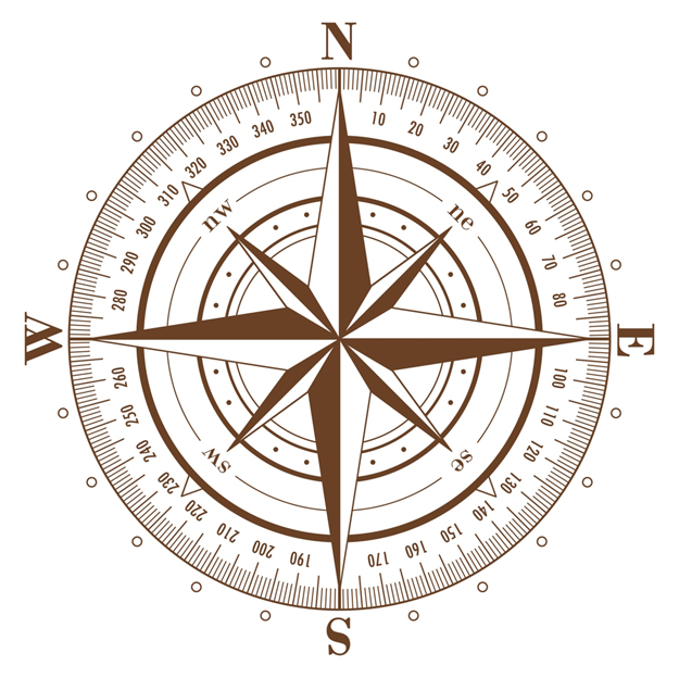
compass_rose_with_bearings.jpgStart at Larch Hill Scout Centre. Car Park. O 145 239
Find grid ref O 145 239 on map (Larch Hill Scout Centre).
Set Compass to bearing of 70 degrees (ENE).
Follow bearing uphill past playground and through cub field for 300m.

  ** counting steps is one way of estimating distance **
  ** how many steps does it take for each person to cross cub field ?

Waypoint 1. Top of Cub field. O 148 240
Set compass to bearing of 20 degrees (NNE).
Climb over fence on to road. (remember leave no trace!)
Follow road NNE for 500m to Kilmashogue Forest car park.

Waypoint 2.  Kilmashogue Forest car park. O 150 244
Set compass to bearing of 160 degrees (SSE).
Follow compass bearing to find some steps and a path, travel 50m up path to Kilmashogue Wedge Tomb.
The chambered cairn at Kilmashogue is known as a wedge tomb. There once was a huge cairn of stones built over the tomb but it has now been quite flattened. You can see the remnants of the surrounding ditch and bank which would have been a lot deeper when it was first constructed around 2000 B.C.

Waypoint 3. Kilmashogue Wedge Tomb. O 151 244
Set compass to bearing of 340 degrees (NNW).
Follow the path back to car park.
Set compass to bearing of 80 degrees.
Follow path East for 400m. Can you find the standing stone ?

Waypoint 4. Kilmashogue Standing Stone. O 154 245
Continue East for another 300m
Path turns to South East. Set compass to 135 degrees (SW) follow path for 600m

Waypoint 5. Wicklow Way Zig Zag. O 160 241
Follow the wicklow way, which Zigs to East(270 degrees) for about 100m.
And then Zags back to South East(135 degrees) and turns to SSE(160 degrees) for 900m.

Waypoint 6. Wicklow Way bend and steps. O 164 232
The path to East goes towards Three Rock Mountain.
The path to South-West and then South up stone flag steps follows the Wicklow Way.
Follow the Wicklow Way path to South: SSW 200 degrees for 200m and SSE 160 degrees for 900m.

Waypoint 7. Wicklow Way - Dublin Mountain Way cross-path O 166 222
The path to East goes towards Two Rock - Fairy Castle.
The path to West goes towards Tibradden.
Set compass to 70 degrees (ENE). Follow path uphill 600m to Two Rock mountain Fairy Castle.

Waypoint 8. Two Rock mountain Fairy Castle. O 172 223 go down NNE (30 degrees) for 1.1km to crossroads.

Waypoint 9. Three Rocks O 177 232.


REVIEW - hike done ?/4/2016 - update 13/5/2016

We gave out compasses and maps with the waypoint list to cubs in groups of 2s and 3s.
I don't like annoying them with a map extra thing to carry and get in the way and take from enjoyment of hike.
BUT on occasion I think is good. Really needed for learning maps.

We asked cubs to look at Waypoint, directions and compass bearing.
Then set compass and follow directions and bearing.
We checked and showed everyone how to set compass at the start.
All cubs going in one direction, some cubs probably not sure what they were doing but other cubs doing ok.

At each waypoint we checked directions and bearings. We kind of got different cub groups to lead a section of hike. Cubs asked questions like how far along legs we were and were looking ahead at next directions.

We had good visit to Wedge Tomb and look around. Rob gave a talk. I told what I know. We didn't want to waste too much time so headed on.

We didn't find the standing stone. Must have walked past it.
Note to self, put the GPS co-ords in and mark it in google maps or viewfinder and we will have better chance of finding it. ALSO turn on MapMyHike/ViewRanger plot or whatever at START and set it in hike mode.

Nice enough day. Cloudy with breaks. We were warm hiking. Cubs mostly took off very warm stuff clothes and hats early on. We didn't stop for breaks too much. When we got to zig-zag we went straight along East towards Three Rock. Lunch on Three Rock. There was a beaver group up there climbing on the rocks. Chilly enough wind at lunch time. We put back on coats etc. Shammy left us at Three Rock.

We then headed for Fairy Castle. Then on towards Tibradden. Pretty gratifying one cub anyway was still following route exactly on map had our location (this after we had finished the wayoints). Good stuff. Small breaks only e.g. look at the tomb/folly on Tibradden. Some cubs getting a bit tired but all in pretty good form. Then back down road to Larch Hill Entrance. Then up the road (we should take cubs up paths cross country to avoid traffic in Larch Hill).

Start of hike up the cub field
Quick break on a log nearing Three Rock

Lunch time top of Three Rock

Path up towards Fairy Castle

Where we came from, view of Kilmashogue from near Fairy Castle top

View of Three Rock masts and Dublin bay in background from Fairy Castle